Geologic Atlas of Texas
-
Books & Reports
- Reports of Investigations
- Guidebooks
- Udden Series
- Geological Circulars
- Down To Earth
- Atlases of Major Oil and Gas Reservoirs
- Texas Memorial Museum Publications
- Environmental Geologic Atlas of the Texas Coastal Zone
- Mineral Resource Circulars
- Other Reports
- Seminars and Workshops
- Handbooks
- Submerged Lands of Texas
- Symposia
- Annual Reports
- Open File Reports
-
Maps & Cross Sections
- Thematic Maps
- Miscellaneous Maps, Charts & Sections
- Geologic Atlas of Texas
- STATEMAP Project Maps
- Geologic Quadrangle Maps
- Cross Sections
- Highway Geology Map
- Energy and Mineral Resource Maps
- Shoreline Change and Other Posters
- Wilcox Group, East Texas, Geological / Hydrological Folios
- Bouguer Gravity Atlas of Texas
- River Basin Regional Studies
- Featured Maps
- Posters
- Teachers & the Public
-
Geological Society Publications
- Gulf Coast Association of Geological Societies
- Alabama Geological Society
- Austin Geological Society
- Corpus Christi Geological Society
- Houston Geological Society
- Lafayette Geological Society
- Mississippi Geological Society
- New Orleans Geological Society
- South Texas Geological Society
- GCS SEPM Publications
- Historic BEG & UT Series


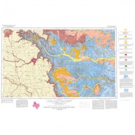
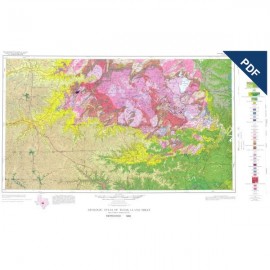
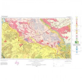
Van Horn-El Paso Sheet. Digital Download
GA0036D
For a print version: GA0036.
Part of the Geologic Atlas of Texas, the Van Horn-El Paso Sheet is an oversize color map that depicts the surface geology of El Paso County and parts of Hudspeth. Jeff Davis, and Culberson Counties, Texas.
Published in honor of E. Russell Lloyd, distinguished Texas independent petroleum geologist, who prior to his death in 1955 edited much of the geological writing concerning the Permian Basin. His geologic interpretation of the Capitan Limestone as a reef, aided in the interpretation of the associated formations and their oil-bearing possibilities. The Capitan Limestone is partly within the area depicted in Van Horn-El Paso Sheet.
Citation:
Dietrich, J. W., Owen, D. E., Shelby, C. A., and Barnes, V. E., 1983, Geologic Atlas of Texas, Van Horn-El Paso Sheet: The University of Texas at Austin, Bureau of Economic Geology, Geologic Atlas of Texas, map scale 1:250,000.