Geologic Quadrangle Maps
-
Books & Reports
- Reports of Investigations
- Guidebooks
- Udden Series
- Geological Circulars
- Down To Earth
- Atlases of Major Oil and Gas Reservoirs
- Texas Memorial Museum Publications
- Environmental Geologic Atlas of the Texas Coastal Zone
- Mineral Resource Circulars
- Other Reports
- Seminars and Workshops
- Handbooks
- Submerged Lands of Texas
- Symposia
- Annual Reports
- Open File Reports
-
Maps & Cross Sections
- Thematic Maps
- Miscellaneous Maps, Charts & Sections
- Geologic Atlas of Texas
- STATEMAP Project Maps
- Geologic Quadrangle Maps
- Cross Sections
- Highway Geology Map
- Energy and Mineral Resource Maps
- Shoreline Change and Other Posters
- Wilcox Group, East Texas, Geological / Hydrological Folios
- Bouguer Gravity Atlas of Texas
- River Basin Regional Studies
- Featured Maps
- Posters
- Teachers & the Public
-
Geological Society Publications
- Gulf Coast Association of Geological Societies
- Alabama Geological Society
- Austin Geological Society
- Corpus Christi Geological Society
- Houston Geological Society
- Lafayette Geological Society
- Mississippi Geological Society
- New Orleans Geological Society
- South Texas Geological Society
- GCS SEPM Publications
- Historic BEG & UT Series


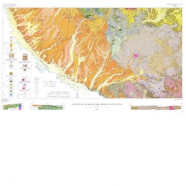
Eastern...Kent Quadrangle, Culberson, Reeves, and Jeff Davis Counties, Texas
GQ0024
For a downloadable, digital version: GQ0024D.
GQ0024. Geology of Eastern Half of Kent Quadrangle, Culberson, Reeves, and Jeff Davis Counties, Texas, by J. P. Brand and R. K. DeFord, 1962. 1 map with text. To purchase this publication as a PDF download, please order GQ0024D.
About This Publication
Study of Permian Cretaceous and Cenozoic rocks in the 30-minute Kent quadrangle is important to an understanding of the geology of Trans-Pecos Texas. This quadrangle is one of the critical areas in determining stratigraphic relations between Central Texas to the east and the geosyncline in Mexico to the west and southwest. The detailed map is on a scale of 1:63,360; a cross section is also included. Four major physiographic features, several stratigraphic units, and the mineral resources of the area are discussed in the accompanying text.
Keywords: maps, geologic maps, Kent quadrangle, Culberson County, Reeves County, Jeff Davis Counties, Texas, West Texas
Citation
Brand, J. P., and DeFord, R. K., 1962, Geology of Eastern Half of Kent Quadrangle, Culberson, Reeves, and Jeff Davis Counties, Texas: The University of Texas, Austin, Geologic Quadrangle Map No. 24, scale 1:63,360.