STATEMAP Project Maps
-
Books & Reports
- Reports of Investigations
- Guidebooks
- Udden Series
- Geological Circulars
- Down To Earth
- Atlases of Major Oil and Gas Reservoirs
- Texas Memorial Museum Publications
- Environmental Geologic Atlas of the Texas Coastal Zone
- Mineral Resource Circulars
- Other Reports
- Seminars and Workshops
- Handbooks
- Submerged Lands of Texas
- Symposia
- Annual Reports
- Open File Reports
-
Maps & Cross Sections
- Thematic Maps
- Miscellaneous Maps, Charts & Sections
- Geologic Atlas of Texas
- STATEMAP Project Maps
- Geologic Quadrangle Maps
- Cross Sections
- Highway Geology Map
- Energy and Mineral Resource Maps
- Shoreline Change and Other Posters
- Wilcox Group, East Texas, Geological / Hydrological Folios
- Bouguer Gravity Atlas of Texas
- River Basin Regional Studies
- Featured Maps
- Posters
- Teachers & the Public
-
Geological Society Publications
- Gulf Coast Association of Geological Societies
- Alabama Geological Society
- Austin Geological Society
- Corpus Christi Geological Society
- Houston Geological Society
- Lafayette Geological Society
- Mississippi Geological Society
- New Orleans Geological Society
- South Texas Geological Society
- GCS SEPM Publications
- Historic BEG & UT Series


Pace Bend Quadrangle, Texas
OFM0221
For a downloadable, digital version: OFM0221D.
This product is no longer in stock
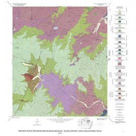
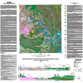
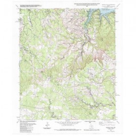
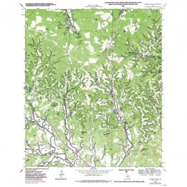
OFM0221. Geologic Map of the Pace Bend Quadrangle, Texas, by C. M. Woodruff, Jr., and E. W. Collins. Oversize geologic map on a color topographic base, map scale 1:24,000, 2015. Includes cross section. For a downloadable PDF: OFM0221D.
ABSTRACT
The Pace Bend Quadrangle lies mostly within Travis County, but it also includes southeastern parts of Burnet County. This map is cut by the meandering courses of the Colorado River and Pedernales River, impounded along the mid reaches of Lake Travis. Landscape in the map area consists of rolling terrain formed on diverse substrate (sandstone, conglomerate, limestone, and local shale). High ground is underlain by hard and soft limestone strata, sculpted into stepped terrain typical of the Central Texas Hill Country. Quaternary alluvial deposits (sand, gravel, silt, and clay) occur as terraces at or above lake level and as discontinuous valley deposits along tributary streams. Also, Quaternary colluvial deposits occur along steep lakeside bluffs that represent areas of potentially unstable slopes.
All of the relatively recent (Quaternary) deposits are of localized areal extent, whereas most of the map comprises basal parts of the Cretaceous section in Central Texas. These Cretaceous units include (in ascending order): Sycamore Sand; Hammett Shale; Cow Creek Limestone; caliche facies of Cow Creek Limestone; Hensel Sand; Lower Member of the Glen Rose Limestone, and Upper Member of the Glen Rose Limestone. This sequence of Cretaceous bedrock units makes up the three parts of the Trinity aquifers that are important sources of groundwater across the Hill Country region. The Upper Trinity aquifer consists of the Upper Member of the Glen Rose Limestone. The Middle Trinity aquifer comprises the Lower Member of the Glen Rose along with the Hensel Sand, and the Cow Creek Limestone (including the caliche facies). The Lower Trinity aquifer consists of the Sycamore Sand, which is equivalent to the Hosston Sand in the subsurface. This unit is separated from the Middle Trinity aquifer by the Hammett Shale, which forms a low-permeability seal.
Keywords: maps, geologic maps, quadrangle maps, Pace Bend, Travis County, Burnet County, Texas
Citation
Woodruff, C. M., Jr., and Collins, E. W., 2015, Geologic Map of the Pace Bend Quadrangle, Texas: The University of Texas at Austin, Bureau of Economic Geology, Open-File Map No. 221, map scale 1:24,000.