Miscellaneous Maps, Charts & Sections
-
Books & Reports
- Reports of Investigations
- Guidebooks
- Udden Series
- Geological Circulars
- Down To Earth
- Atlases of Major Oil and Gas Reservoirs
- Texas Memorial Museum Publications
- Environmental Geologic Atlas of the Texas Coastal Zone
- Mineral Resource Circulars
- Other Reports
- Seminars and Workshops
- Handbooks
- Submerged Lands of Texas
- Symposia
- Annual Reports
- Open File Reports
-
Maps & Cross Sections
- Thematic Maps
- Miscellaneous Maps, Charts & Sections
- Geologic Atlas of Texas
- STATEMAP Project Maps
- Geologic Quadrangle Maps
- Cross Sections
- Highway Geology Map
- Energy and Mineral Resource Maps
- Shoreline Change and Other Posters
- Wilcox Group, East Texas, Geological / Hydrological Folios
- Bouguer Gravity Atlas of Texas
- River Basin Regional Studies
- Featured Maps
- Posters
- Teachers & the Public
-
Geological Society Publications
- Gulf Coast Association of Geological Societies
- Alabama Geological Society
- Austin Geological Society
- Corpus Christi Geological Society
- Houston Geological Society
- Lafayette Geological Society
- Mississippi Geological Society
- New Orleans Geological Society
- South Texas Geological Society
- GCS SEPM Publications
- Historic BEG & UT Series


Central Hueco Bolson, Acala-Fort Hancock-Esperanza Region, Texas
MM0042
For a downloadable, digital version: MM0042D.
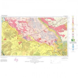
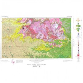
MM0042. Geologic Map of the Central Hueco Bolson, Acala-Fort Hancock-Esperanza Region, Texas, by E. W. Collins and J. A. Raney. Oversize color map, scale 1:100,000, and 26-p. text, 2002.
To purchase this publication as a PDF download, please order MM0042D.
About This Publication
This surface geologic map shows the areal distribution of bedrock basin-fill and surficial geologic units and primary geologic structural elements such as faults and bedding attitudes of the Central Hueco Bolson in West Texas. Construction of the map entailed field mapping and use of aerial photographs, existing maps, and the authors' 1:24,000-scale, open-file geologic maps that were digitized, coded, and compiled in a Geographic Information System. This map is an essential data set for part of the Texas-Mexico border area that is undergoing urban growth, diminishing water resources, and environmental stress due to development.
Keywords: maps, geologic maps, Hueco Bolson, Acala area, Fort Hancock area, Esperanza area, West Texas, Texas, Mexico, border area
Citation
Collins, E. W., and Raney, J. A., 2002, Geologic Map of the Central Hueco Bolson, Acala-Fort Hancock-Esperanza Region, Texas: The University of Texas at Austin, Bureau of Economic Geology, Miscellaneous Map No. 42, 1 map, scale 1:100,000, and 26-p. text.