UT Bulletins
-
Books & Reports
- Reports of Investigations
- Guidebooks
- Udden Series
- Geological Circulars
- Down To Earth
- Atlases of Major Oil and Gas Reservoirs
- Texas Memorial Museum Publications
- Environmental Geologic Atlas of the Texas Coastal Zone
- Mineral Resource Circulars
- Other Reports
- Seminars and Workshops
- Handbooks
- Submerged Lands of Texas
- Symposia
- Annual Reports
- Open File Reports
-
Maps & Cross Sections
- Thematic Maps
- Miscellaneous Maps, Charts & Sections
- Geologic Atlas of Texas
- STATEMAP Project Maps
- Geologic Quadrangle Maps
- Cross Sections
- Highway Geology Map
- Energy and Mineral Resource Maps
- Shoreline Change and Other Posters
- Wilcox Group, East Texas, Geological / Hydrological Folios
- Bouguer Gravity Atlas of Texas
- River Basin Regional Studies
- Featured Maps
- Posters
- Teachers & the Public
-
Geological Society Publications
- Gulf Coast Association of Geological Societies
- Alabama Geological Society
- Austin Geological Society
- Corpus Christi Geological Society
- Houston Geological Society
- Lafayette Geological Society
- Mississippi Geological Society
- New Orleans Geological Society
- South Texas Geological Society
- GCS SEPM Publications
- Historic BEG & UT Series


BL2745. Exploratory Geology of a Part of Southwestern Trans-Pecos Texas, by C. L. Baker. 70 p., 1 map, 1927.
From the Introduction
The region treated in the present paper is bounded on the north by the line of the Texas & Pacific Railway, on the west by the Malone Mountains, on the southwest by the Rio Grande, and on the east practically by the line 104" 30' west longitude. The fieldwork was done at the rate of about thirty-five square miles per day. Much of the mapping was schematic and thicknesses of rock sections were estimated. The structure proved to be complicated and only the main structural features were determined.
Keywords: Malone Mountains, Texas, Trans-Pecos Texas
CONTENTS
Introduction
Review of Previous Explorations
Stratigraphy
Pre-Cambrian
Carrizo schist
Upper Cambrian
Van Horn sandstone
Permian
Summary of the Mesozoic Stratigraphy
Jurassic
Malone Beds
Lower Cretaceous
Etholen Conglomerate
Cox sandstone
Finlay limestones
Fredericksburg
Washita
Upper Cretaceous
Late Cretaceous Mountain-making
Volcanism
Mid-Tertiary Deformation
Epoch of Basin-filling and Rio Grande Basin Lake Deposits
Latest Epoch
Probable earthquake cracks
Structure
Physiography
Geologic History
Economic Geology
Oil and Gas Products
Ore Deposits
Non-Metallic Minerals
Index
ILLUSTRATION
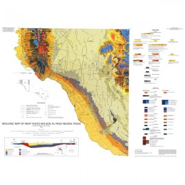
Plate 1. Exploratory Geologic Map of a part of Southwestern Trans-Pecos Texas
Citation
Baker, C. L., 1927, Exploratory Geology of a Part of Southwestern Trans-Pecos Texas, by C. L. Baker. 70 p.