STATEMAP Project Maps
-
Books & Reports
- Reports of Investigations
- Guidebooks
- Udden Series
- Geological Circulars
- Down To Earth
- Atlases of Major Oil and Gas Reservoirs
- Texas Memorial Museum Publications
- Environmental Geologic Atlas of the Texas Coastal Zone
- Mineral Resource Circulars
- Other Reports
- Seminars and Workshops
- Handbooks
- Submerged Lands of Texas
- Symposia
- Annual Reports
- Open File Reports
-
Maps & Cross Sections
- Thematic Maps
- Miscellaneous Maps, Charts & Sections
- Geologic Atlas of Texas
- STATEMAP Project Maps
- Geologic Quadrangle Maps
- Cross Sections
- Highway Geology Map
- Energy and Mineral Resource Maps
- Shoreline Change and Other Posters
- Wilcox Group, East Texas, Geological / Hydrological Folios
- Bouguer Gravity Atlas of Texas
- River Basin Regional Studies
- Featured Maps
- Posters
- Teachers & the Public
-
Geological Society Publications
- Gulf Coast Association of Geological Societies
- Alabama Geological Society
- Austin Geological Society
- Corpus Christi Geological Society
- Houston Geological Society
- Lafayette Geological Society
- Mississippi Geological Society
- New Orleans Geological Society
- South Texas Geological Society
- GCS SEPM Publications
- Historic BEG & UT Series


Rincon Bend quadrangle, Texas
OFM0218
For a downloadable, digital version: OFM0218D.
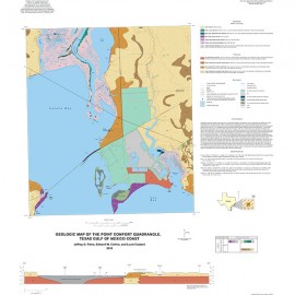
OFM0218. Geologic Map of the Rincon Bend Quadrangle, Aransas River and Copano Bay Area, Texas Gulf of Mexico Coast, by J. G. Paine, E. W. Collins, and Lucie Costard. Oversize color map on topographic base, map scale 1:24,000, 2015. Paper map. For a downloadable PDF: OFM0218D.
About This Publication
The geologic map of the Rincon Bend Quadrangle illustrates the geology of the Aransas and Mission rivers/deltas area at Copano Bay, Texas Gulf of Mexico Coast. The map of this quadrangle depicts part of the Aransas River and delta. Geology of the area partly consists of upland Pleistocene Lissie fluvial sand, silt, clay, and lesser gravel, as well as Beaumont clay, silt, sand, and minor gravel of fluvial–deltaic interdistributary and distributary settings. Sand-rich channelfacies of the Lissie and Beaumont Formations are displayed. Modern to Holocene fluvial floodplain, levee, crevasse splay, point bar, clay dune, channel-bar, and terrace deposits occur within the Aransas River valley. Delta-plain deposits and tidal flats are adjacent to Copano Bay.
Keywords: maps, geologic maps, Rincon Bend Quadrangle, Aransas River area, Copano Bay area, Texas coast, Texas
Citation
Paine, J. G., Collins, E. W., and Costard, Lucie, 2015, Geologic Map of the Rincon Bend Quadrangle, Aransas River and Copano Bay Area, Texas Gulf of Mexico Coast: The University of Texas at Austin, Bureau of Economic Geology, Open-File Map No. OFM0218, map scale 1:24,000.